Erie County has almost 100 historical markers. You can find maps for most of these on Remarkable Ohio Just click on Erie County for the list of markers. Another great resource is The Historical Marker Database. volunteer driven it includes easy to follow directions to locations and a history of sponsorship.
These markers are scattered throughout Erie County—along roads and streets, in front of buildings, in parks and parking lots, along trails—but the majority are located in Sandusky and Huron and Huron Township. The database in our website identifies each marker by name, and location. An image of each marker is also included in the database. Each marker highlights something significant in the story of Erie County—a special event, a unique structure, the birthplace of a notable person. The list is long and varied. Taken together, they represent much of the significant history of the county.
The Erie County Historical Society is committed to maintaining the 24 markers it has sponsored and has set up a program of regular maintenance for each marker. Some are 60 years-old, others are relatively new. The Ohio History Connection is responsible for administering the Ohio Historical Marker program on a state-wide basis. The program “identifies, commemorates, and honors the people, places, and events that have contributed to the state’s rich history.” More information about the program, including a database of all historic markers in the state of Ohio, is available through a special website maintained by the OHC: www.remarkableohio.org
Looking for a particular marker? Click on the city to jump around in the list.
City of Sandusky
Perkins Township
Bay View, Castalia and Margaretta Township
Huron City & Huron Township
Oxford Township
Vermilion City, Vermilion Township & Brownhelm
Village of Milan, Milan Twp & Avery
Birmingham
Kelleys Island
City of Sandusky Historical Markers
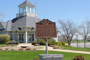
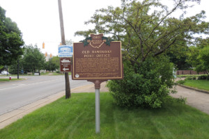 OLD SANDUSKY POST OFFICE
301 W Washington St, Sandusky OH
This U.S. Post Office building, Sandusky’s third, opened in 1927, replacing a smaller building at Columbus Avenue and Market Street. It is notable for its fine Neoclassical-style architecture and its unusual curved portico. It was added to the National Register of Historic Places in 1982. For sixty years it served as Sandusky’s business center, where merchants shipped and received goods and banks transferred money. During this time it also housed local offices for several federal agencies, including U.S. Customs, the National Weather Service, armed forces recruiting, and the Federal Bureau of Investigation. The U.S. Geological Survey disk embedded in the front steps serves as a benchmark for surveyors and scientists. Closed in 1987, the historic Sandusky Post Office building reopened as the Merry-Go-Round Museum in 1990.
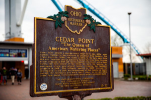 CEDAR POINT – THE QUEEN OF AMERICAN WATERING PLACES
1 Cedar Point Dr.
Cedar Point became a popular beach resort in the late 1870s, when visitors traveled to the peninsula by steamboat from Sandusky. The Grand Pavilion (1888), the oldest building in the park, dates from this era. Promoter George Boeckling formed the Cedar Point Pleasure Resort Company in 1897 and vastly expanded the resort’s attractions. During the first decade of the 1900s, he built the lagoons, an amusement circle, and several hotels, including the landmark Breakers in 1905. The Coliseum, opened in 1906, became the centerpiece of the park and hosted many of the famous big bands through the Depression and World War II years. In the late 1950s, Cedar Point began its transformation into a modern amusement park.
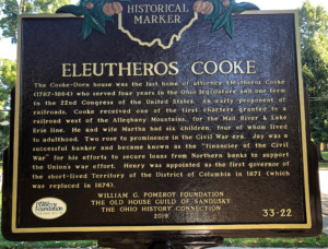
ELEUTHEROS COOKE – COOKE-DORN HOUSE
1415 Columbus Rd., Sandusky OH
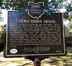 Side B: The house is named for its first and last private owners. Built for Eleutheros and Martha Cooke in 1843-1844, this Greek Revival home was originally located on the corner of Columbus Avenue and West Washington Row. Rush Sloane dismantled and reassembled the house at 1415 Columbus Avenue in 1879-1880. Once moved, his son Thomas and daughter-in-law, Sarah Cooke Sloane, grand-daughter of Eleutheros and Martha, lived here. Judge Roy and Verna Williams became the third owners in 1922. Randolph and Estelle Dorn bought the hous
THE CONCRETION
This plaque is located on a large spherical concretion, discovered in 1910. This unusual geological formation is located in downtown Sandusky in Washington Park between Columbus Ave. and Wayne St., near the Gazebo.
This concretion was formed in sedimentary deposits over the ages. An unusually large specimen, it was found in 1911 on Mills Street and brought to this site at the behest of Prof. E. L. Moseley, who was noted for his studies of Lake Erie and his natural history museum. It was on a pedestal in this park for about eighty years. In 1990 it was partially burned to halt deterioration.
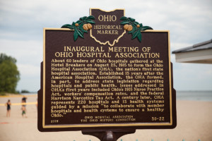 INAUGURAL MEETING OF THE OHIO HOSPITAL ASSOCIATION
This marker is inside Cedar Point and you may need to apply ahead for permission to enter without parking fee.
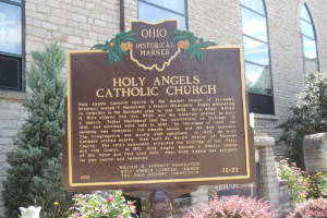 HOLY ANGELS CATHOLIC CHURCH
428 Tiffin Ave., Sandusky OH
Holy Angels Catholic Church is the mother church of Sandusky. Reverend Joseph P. Machebeuf, a French Missionary, began ministering to Catholics in the Sandusky area in late 1839. Soon after, William H. Mills offered five lots, $530, and the materials needed to build a church. Father Machebeuf laid the cornerstone on October 13, 1841, and services were held in 1842. By Christmas of 1845, the building was complete, the steeple added, and the bell installed. The congregation was mostly Irish emigrants. In 1855, as more Germans settled nearby, they built St. Mary’s Mother of Sorrows Church. The city’s expansion prompted the building of Sts. Peter and Paul Church in 1871. Holy Angels became a mission church of Sts. Peter and Paul until 1875 when Holy Angels was assigned its own pastor and reopened.
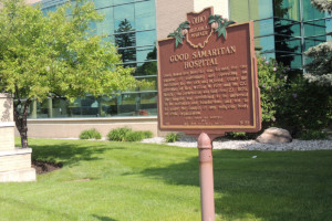 GOOD SAMARITAN HOSPITAL
1111 Hayes Ave., Street, Sandusky OH (in front of Firelands Hospital)
Good Samaritan Hospital was formed for the purpose of maintaining and operating an institution for the sick and injured. Under the direction of Rev. William W. Farr and Mr. C.C. Keech, the cornerstone was laid June 27, 1976. The hospital was established to be universal in its activities and benefactors and not to be under the control of any religious body or civic organization.
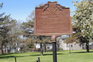 CHOLERA CEMETERY – IN HONOR OF THE DOCTORS
Corner of Harrison & Jefferson Sts.
Side A: Of the city’s 5,667 people in 1849, 3,500 fled, and 400 of those remaining were victims of cholera. Most are buried here, some only in rough boxes in a common grave. The scourge came again in 1850 and 1852 but with less toll. “Dismay stalked abroad in the daytime and the drowsy night was hideous with the wailings of the disconsolate.” Learn more about this historic site.
 Side B: Doctors, nurses and others assisted in fighting the cholera in 1849, aiding heroic citizens led by Foster M. Follett. Doctors Austin, Brainard, Lane and Tilden suffered illness and exhaustion, leaving Dr. Cochran alone among Sandusky doctors until aid came. Drs. Ackley, Beaumont, Lauderdale and Spencer, and Messrs. Dolan and Miller of Cleveland; Drs. Banks, Caroland, Follen, Foote, Hughes, Lindsey, Ocheltree, Quinn and Raymond, and Messrs. Bailey, Hindale and Yorke, Mrs. Cowden and nurses from Cincinnati; Dr. Appleton of Philadelphia; Dr. Stanley of Canton; Drs. Evans and Pack of Akron; Drs. Glick and Teagarden of Mansfield; Dr. Vance of Urbana; and Mr. and Miss Rushton of Bellevue. “They came emphatically in our time of need, and faithfully and successfully did they minister relief to the distressed and the dying. Long will be e’er the citizens of Sandusky forget their kindness.”
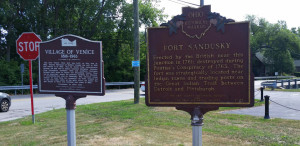 FORT SANDUSKY
Located at the intersection of Routes 2 and 6 with Route 99 in the community of Venice, which is now a part of Sandusky (near Margaritaville).
This marker was damaged and is currently being cast with updated language.
Erected by the British near this junction in 1761; destroyed during Pontiac’s Conspiracy of 1763. The fort was strategically located near Indian towns and trading posts on the Great Indian trail between Detroit and Pittsburgh. READ MORE
VILLAGE OF VENICE 1816-1963
Side A – Located at the intersection of Routes 2 and 6 with Route 99 in the community of Venice, which is now a part of Sandusky (near Margaritaville).
The first Venice flour mill was built on this site in 1811. Russell Heywood from Buffalo bought the mill in 1831 and rebuilt it in 1833. Fed by water from underground springs, the mill was in almost constant operation. Farmers from throughout northern Ohio and southern Michigan brought their grain to Venice for processing. Venice flour was an important staple for pioneers settling the Midwest. A six hundred foot pier on Sandusky Bay allowed cargo vessels to load flour for transport. By 1875, demand led to day and night shifts at the mill. After 122 years, the mill closed in 1945. The building was razed in 1962.
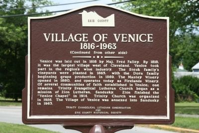 Side B – Venice was laid out in 1816 by Maj. Fred Falley. By 1818, it was the largest village west of Cleveland. Venice took part in the region’s wine industry. The Steuk family’s vineyards were planted in 1865, with the Dora family beginning grape production in 1869. The Mantey Winery opened in 1880, and operates today as Firelands Winery. Of several communities of faith established in Venice; one remains. Trinity Evangelical Lutheran Church began as a mission of Zion Lutheran, Sandusky. Zion finished the “Venice Chapel” in 1914. Trinity Church was organized in 1926. The Village of Venice was annexed into Sandusky in 1963.
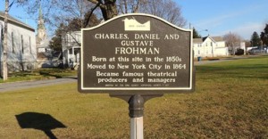 FROHMAN BIRTHPLACE
Located on Poplar St, near the intersection of Lawrence and W Jefferson Sts. Sandusky OH
Charles, Daniel and Gustave Frohman. Born at this site in the 1850s. Moved to New York City in 1864. Became famous theatrical producers and managers.
The Frohman Birthplace marker is not in its original location. The Frohman children mentioned on this marker actually were born in the house at 507 Lawrence Street, and this marker was originally placed in the front yard of the house in 1971. When the home was sold sometime after this marker was installed, the new owners wanted it removed from their yard and it was moved to its current location.
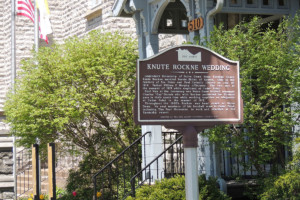 KNUTE ROCKNE WEDDING
510 Columbus Ave., Sandusky OH
READ MORE about how he met and married his wife. The Knute Rockne Wedding Historical Marker is featured on the Washington Park Historic Walking Tour. Learn more about this historic church.
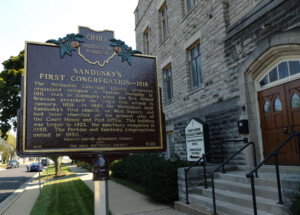 SANDUSKY’S FIRST CONGREGATION – 1818
214 E Jefferson St., Sandusky OH
The Trinity United Methodist Church is featured on the Washington Park Historic Walking Tour.
Learn more about this historic site.
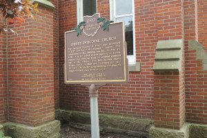
The Methodist Episcopal Church pioneered organized religion in Perkins Township in 1811, then in Sandusky when the Rev. Alfred Brunson preached the city’s first sermon in January, 1818. In 1829 the Methodists built Sandusky’s first church, on West Square, and had later churches on the present sites of the Court House and Post Office. This building was begun in 1922, the sanctuary completed in 1958. The Perkins and Sandusky congregations united in 1930. This marker was refurbished by the Church in 2024.
 (ORIGIN OF) THE FIRELANDS
1111 Hayes Ave., Sandusky OH – Located in front of Firelands Hospital
The Origin of the Firelands markers in front of both Firelands Hospital and BGSU Firelands were installed around the same time and the text on each is exactly the same.
Text: The history of the Firelands is linked to the American Revolutionary War. During the British raids of 1777 and 1779 the Connecticut towns of Danbury, East Haven, New Haven, Fairfield, Norwalk, Greenwich, Groton, Ridgefield and New London were destroyed by fire. In 1781 the last major British raid was commanded by Benedict Arnold, who had turned traitor. Lives were lost and many homes and shops were burned. For ten years the townspeople petitioned the General Assembly of Connecticut for relief. The Assembly was sympathetic with their plight but they were unable to make restitution. Finally on May 10, 1792 the Connecticut legislature set aside 500,000 acres of land for the sufferers. The tract was In the western most part of the Connecticut Western Reserve in what is now the state of Ohio, named the Fire Sufferers Land or Fire Land. The tract consists of all of the present-day counties of Huron and Erie as well as Danbury Township in Ottawa County and Ruggles Township in Ashland County. Many of the new Firelands communities were named for their Connecticut counterparts. After years of delay, only a few of the original “Sufferers” were able to move to the new land; most were too old to migrate. Their younger heirs either made the move or sold the land.
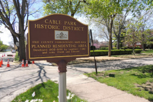 CABLE PARK HISTORIC DISTRICT
Located on Wayne St. near Finch on the center median.
Erie County Fairgrounds — 1865-1899.
Planned Residential Area developed 1905-1938 by Laurence Cable and sons, Fran and Edward. Erected 1989 by the Erie County Historical Society and Cable Park Neighbors.
Read about the Cable family and Cable Park in this Sandusky Library Blog post
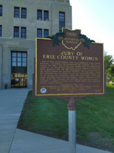 ERIE COUNTY COURTHOUSE/JURY OF ERIE COUNTY WOMEN
323 Columbus Ave., Sandusky OH
Side A: Jury of Erie County Women, First to be Impaneled Under Federal Suffrage proclaimed the headline of the Sandusky Register on August 28, 1920. One of the first female Court of Common Pleas juries in the nation was impaneled in Erie County on August 26, 1920, moments after the 19th amendment to the Constitution of the United States was declared ratified. On that date, Judge Roy Williams was to conduct a trial and jurors were needed. Out of the ten men he contacted, only one could serve. Frustrated, Judge Williams later told the women, “When I learned shortly after 10:30 this morning that suffrage had been proclaimed, I decided to impanel a woman jury. Twelve women were summoned. Twelve women served.” READ MORE
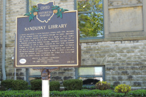 ERIE COUNTY JAIL/SANDUSKY LIBRARY
114 W Adams St., Sandusky OH
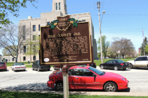 Side B: The Erie County Jail was built in 1882-1883 in the Gothic style. Constructed of blue limestone, the $45,750 facility featured 26 cells, the sheriff’s residence, and boasted then modern innovations including chrome steel bars and safety mechanisms. A number of city and county jails existed in the city during Sandusky’s early years; however, this building stood the test of time and was used until replaced by a modern facility in 1990. Sheriffs and their families lived in the residence until 1972, when it was converted to office space. The Erie County Jail was listed on the National Register of Historic Places in 1982. In 2004 the building was incorporated into the newly renovated and expanded Sandusky Library.
This site is featured on the Washington Park Historic Walking Tour. Learn more about this historic marker.
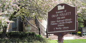 ORAN FOLLETT RESIDENCE/FOLLETT HOUSE MUSEUM
Not currently viewable. Formerly located at 404 Wayne St., Sandusky OH
The Oran Follett Residence/Follett House Museum marker has been removed because it fell down and the library took it into the museum. They are working on securing a new Ohio Historic Marker as a replacement.
Residence of Oren Follett 1798-1894 — Editor – Railroad Official — Publisher Lincoln-Douglas debate — A Worthy Citizen. The Follett House is featured on the Washington Park Historic Walking Tour and the Underground Railroad Historic Walking Tour.
Learn more about this historic site.
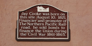 BIRTHPLACE OF JAY COOKE
Corner of Market St. & Columbus Ave., Sandusky OH
Jay Cooke was born on this site August 10, 1821. Financier and promoter of The Northern Pacific Railroad, he sold bonds to finance the Union during the Civil War 1861-1865.
This plaque was mounted on the wall of the Cooke Building; however, during a remodeling project, it was discovered that there were critical problems with the structural integrity of the building. It was demolished and a new, similar building built in its place. This plaque was removed and has not been reinstalled yet.
The history of this building is featured on the Downtown Sandusky Historic Walking Tour
Learn more about Jay Cooke.
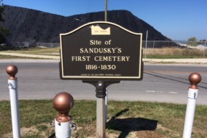 FIRST CEMETERY IN SANDUSKY
No longer viewable
Site of Sandusky’s First Cemetery
1816-1830
The history of this cemetery can be found here: READ MORE
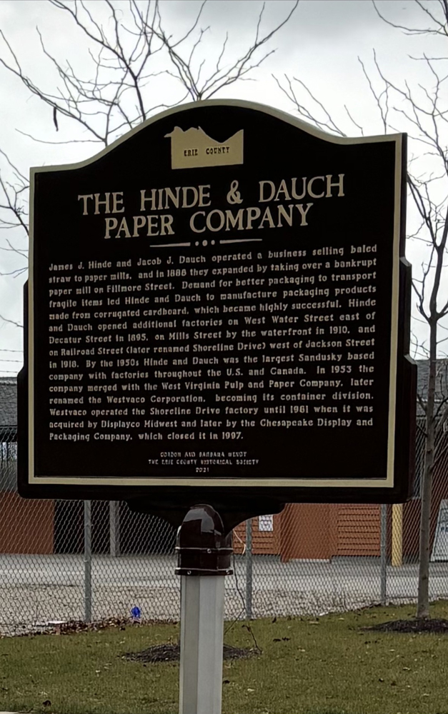 HINDE & DAUCH PAPER COMPANY & THE PAPER DISTRICT
300 W. Shoreline Dr., Sandusky OH
SIDE 1 – HINDE & DAUCH – James J. Hinde and Jacob J. Dauch operated a business selling baled straw to paper mills, and in 1888 they expanded by taking over a bankrupt paper mill on Fillmore Street. Demand for better packaging to transport fragile items led Hinde and Dauch to manufacture packaging products made from corrugated cardboard, which became highly successful. Hinde and Dauch opened additional factories on West Water Street east of Decatur Street in 1895, on Mills Street by the waterfront in 1910, and on Railroad Street (later renamed Shoreline Dive) west of Jackson Street in 1918. By the 1950s Hinde and Dauch was the largest Sandusky based company with factories throughout the U.S. and Canada. In 1953 the company merged with the West Virginia Pulp and Paper Company, later renamed the Westvaco Corporation, becoming its container division. Westvaco operated the Shoreline Drive factory until 1981 when it was acquired by Displayco Midwest and later by the Chesapeake Display and Packaging Company, which closed it in 1997. Made possible through a donation by GORDON AND BARBARA WENDT Learn more about this marker. The Hinde and Dauch Co. is featured on the Downtown Sandusky Historic Walking Tour.
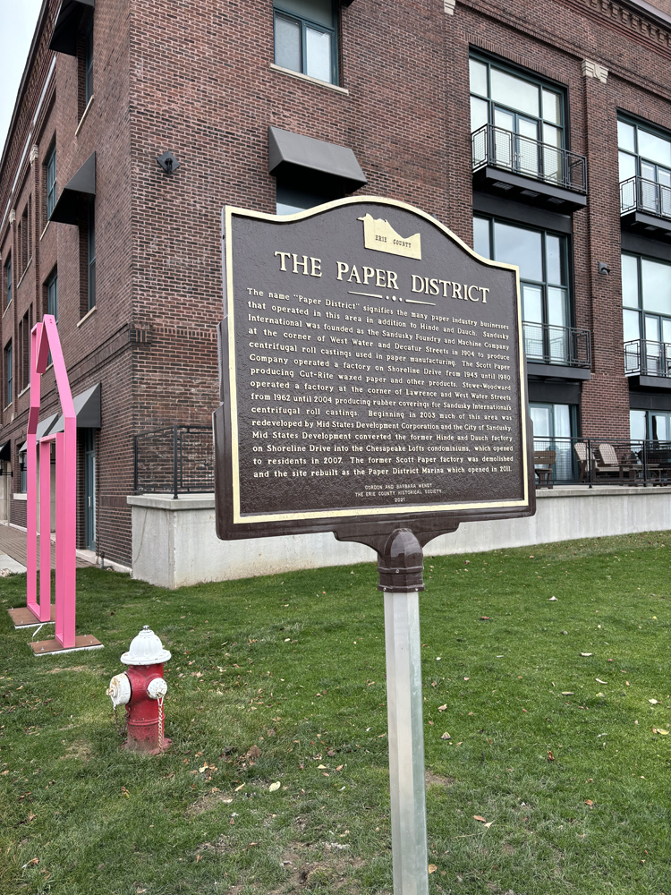 Side 2 – THE PAPER DISTRICT
The name “Paper District” signifies the many paper industry businesses that operated in this area in addition to Hinde and Dauch. Sandusky International was founded as the Sandusky Foundry and Machine Company at the corner of West Water and Decatur Streets in 1904 to produce centrifugal roll castings used in paper manufacturing. The Scott Paper Company operated a factory on Shoreline Drive from 1945 until 1980 producing Cut-Rite waxed paper and other products. Stowe-Woodward operated a factory at the corner of Lawrence and West Water Streets from 1962 until 2004 producing rubber coverings for Sandusky International’s centrifugal roll castings. Beginning in 2003 much of this area was redeveloped by Mid States Development Corporation and the City of Sandusky. Mid States Development converted the former Hinde and Dauch factory on Shoreline Drive into the Chesapeake Lofts condominiums, which opened to residents in 2007. The former Scott Paper factory was demolished and the site rebuilt as the Paper District Marina which opened in 2011. Made possible through a donation by GORDON AND BARBARA WENDT
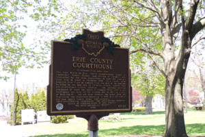
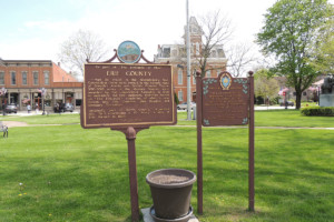
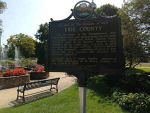 ERIE COUNTY
Located in Washington Park, downtown Sandusky OH
Erie County had its origin during the Revolutionary War when several towns on the Connecticut Coast were burned by the British. 500,000 acres in the Connecticut Western Reserve in Northern Ohio were awarded by the Connecticut Assembly in 1792 to indemnify the fire-sufferers. This area, which came to be known as the Firelands, was purchased from the Indians in 1805 and surveyed in 1809 when settlement finally began. The Firelands, which included modern day Huron and Erie Counties, Ruggles Township in Ashland County and Danbury Township in Ottawa County was designated as Huron County by the Ohio Assembly. In 1838, Margaretta, Groton, Oxford, Perkins, Portland, and Danbury Townships and Kelley’s Island formed the new Erie County with the City of Sandusky as its county seat. In 1840, Milan, Huron, Berlin, Florence and Vermilion Townships joined the Erie County and Danbury Township was absorbed into the newly organized Ottawa County. The Erie County Historic Marker is featured on the Washington Park Historic Walking Tour. This marker was refurbished in 2024 through a cooperate effort by the Erie County Historical Society and the City of Sandusky.
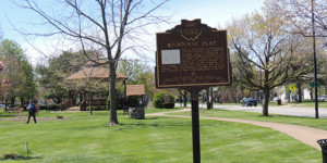 KILBOURNE PLAT
Located in Washington Park near Wayne Street.
In 1817, James Kilbourne met Isaac Mills and Zalmon Wildman, the owners of the land where Sandusky now stands, and convinced them to pool their resources in order to establish a new city on the south shore of Sandusky Bay …. Learn more about this marker. The Kilbourne Plat Historic Marker is featured on the Washington Park Historic Walking Tour.
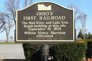 OHIO’S FIRST RAILROAD
Corner of E Water St & Meigs St.
The Mad River and Lake Erie began building at this site September 15, 1835. William Henry Harrison officiated.
Read about the Mad River RR HERE and about William Henry Harrison HERE on the Sandusky Library’s website.
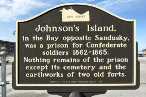 JOHNSON’S ISLAND
300 W. Shoreline Dr., Sandusky OH
Johnson’s Island
In the Bay opposite Sandusky, was a prison for Confederate soldiers 1862-1865.
Nothing remains of the prison except its cemetery and the earthworks of two old forts.
There is another Johnson’s Island historic marker in Ottawa County at the entrance to the causeway to the Island. The Johnson’s Island Historical Marker is featured on the Downtown Sandusky Historic Walking Tour.
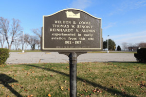 EARLY AVIATION
Located near the corner of E Water St. and Meigs St.
Weldon B. Cooke, Thomas W. Benoist, Reinhardt N. Ausmus
experimented in early aviation from this site 1912-1917
View some great photos and read about aviation in Sandusky as well as these men on the Sandusky Library History Blog: Weldon B. Cooke, Thomas W. Benoist, & Reinhardt N. Ausmus
 THE UNDERGROUND RAILROAD/ABOLITION BOATS PROVIDE AN ESCAPE TO FREEDOM IN ERIE COUNTY
Location: Shoreline Park, near 411 East Shoreline Drive, Sandusky OH
Side 1: The Underground Railroad was neither underground nor a railroad, but a system of loosely connected safe havens where those escaping the brutal conditions of slavery were sheltered, fed, clothed, nursed, concealed, disguised, and instructed during their journey to freedom. Although this movement was one of America’s greatest social, moral, and humanitarian endeavors, the details about it were often cloaked in secrecy to protect those involved from retribution of civil law and slave-catchers. Ohio’s history has been permanently shaped by the thousands of runaway slaves passing through or finding permanent residence in this state
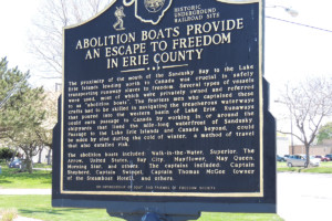 Side 2: The proximity of the mouth of the Sandusky Bay to the Lake Erie Islands leading north to Canada was crucial in safely transporting runaway slaves to freedom. Several types of vessels to as “abolition boats”. The fearless men who captained these crafts had to be skilled in navigating the treacherous waterways that poured into the western basin of Lake Erie. Runaways could earn passage to Canada by working in or around the shipyards that lined the mile-long waterfront of Sandusky. Passage to the Lake Erie Islands and Canada beyond, could be made by sled during the cold of winter, a method of travel that also entailed risk. The abolition boats included: Walk-in-the-Water, Superior, The Arrow, United States, Bay City, Mayflower, May Queen, Morning Star, and others. The captains included: Captain Shepherd, Captain Swiegel, Captain Thomas McGee (owner of the Steamboat Hotel), and others.
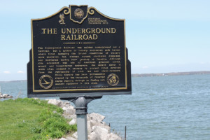
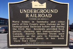 UNDERGROUND RAILROAD
Location: near 200 Shoreline Drive, Sandusky OH
Many homes in Sandusky and other parts of Erie County were stations on the Underground Railroad before and during the Civil War. Residents provided food, shelter, clothing and transportation to Canada. Harriet Beecher Stowe used Sandusky as the gate to freedom for the run away slaves in her book Uncle Tom’s Cabin.
The Underground Railroad Historical Marker is featured on the Downtown Sandusky Historic Walking Tour. Learn more about this marker.
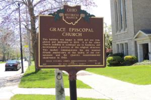 GRACE EPISCOPAL CHURCH
315 Wayne St., Sandusky OH
Grace Church is the oldest church in Sandusky with part of the original building incorporated into the present church. The 18-inch-thick exterior walls rise from the bedrock limestone, that underlies most of Sandusky. READ MORE
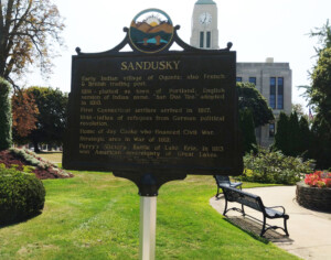 CITY OF SANDUSKY
Located in Washington Park on the grounds of the Erie County Courthouse near E. Washington St.
In 1816, Zalmon Wildman, a citizen of Connecticut, platted “Sandusky City” in Portland Township on the south shore of Sandusky Bay on the site formerly occupied by the Indian chief, Ogontz….. Read more about this historic marker. The City of Sandusky Historic Marker is featured on the Washington Park Historic Walking Tour. This marker was refurbished in 2024 through the cooperative effort of the Erie County Historical Society and the City of Sandusky.
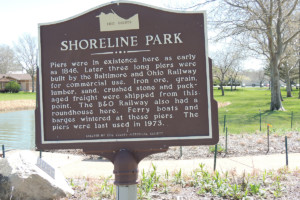 SHORELINE PARK
411 East Shoreline Dr., Sandusky OH
Piers were in existence here as early as 1846. Later, three long piers were built by the Baltimore and Ohio Rilway for commercial use. Iron ore, grain, lumber, and crushed stone and packaged freight were shipped from this point. The B&O Railway also had a roundhouse here. Ferry boats and barges wintered at these piers. The piers were last used in 1973.
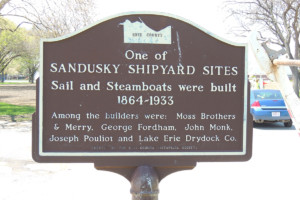 SANDUSKY SHIPYARDS
Located near E Water St. & Meigs St.
One of Sandusky Shipyard Sites
Sail and Steamboats were built 1864-1933
Among the builders were: Moss Brothers & Merry, George Fordham, John Monk, Joseph Pouliot and Lake Erie Drydock Co.
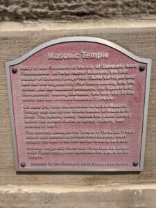 THE MASONIC TEMPLE
304 Wayne St.
On December 20, 1886 a joint communication from Science Lodge 50 and Perseverance #329 suggested that a Masonic Home be built in Sandusky. The construction started in 1888 and the cornerstone was laid on June 24, 1889. READ MORE about the Masons and this historic building. This building is on our Washington Park Walking Tour.
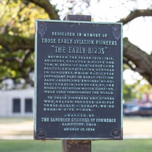 THE EARLY BIRDS OF AVIATION – This marker is located on West Washington Street in Washington Park, just west of the Boy with the Boot. It is under the trees, and behind the bench. Dedicated in memory of those early aviation pioneers “The Early Birds” 1910-1917. READ MORE
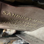
BICENTENNIAL ROSE GARDEN
Gone but not forgotten (original plaque in storage)
Formerly located at Sycamore Line and Cleveland Road
Sandusky Jaycees Bicentennial Rose Garden, donated to our city July 2, 1976 READ MORE
Perkins Township Historical Markers
 THE PIPE CREEK BRIDGE
Located on Columbus Ave. just south of King Street
The previous bridge which carried Columbus Avenue over Pipe Creek was a two-span, filled, spandrel, segmental stone arch. Sandusky firm J. Py & Crackstetter was the lowest bidder at 29 cents per cubic foot of stone. Erie County awarded the construction contract on March 28, 1887. The total cost to build the bridge was $7,199.19.
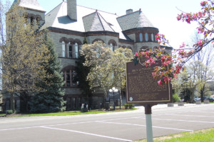
In 1886 the Ohio legislature authorized the creation of the Ohio Soldiers and Sailors Home (now the Ohio Veterans Home) for veterans of the Civil War. A commission appointed by Governor J.B. Foraker and chaired by I.F. Mack of Sandusky chose the present site in Perkins Township one mile south of Sandusky, to be the location of the home. Construction began in 1887 and the first veterans were admitted for residence in November 1888.
The Pipe Creek Bridge was one of a series of projects to improve the roadway connections from Sandusky to the Ohio Soldiers and Sailors Home. In addition to the bridge, Erie County also awarded contracts to widen and macadamize Columbus Avenue and Milan Road from Perkins Avenue to the Home, as well as construct a stone arch bridge on Milan Road over Pipe Creek (demolished in 1970).
Stone arches have been constructed since pre-Roman times and were preferred where strength and longevity were important. While wrought iron truss bridges were becoming common, this bridge’s short span – 40 feet – and exceptional width – 99 feet – made trusses impractical. Steel bridges were still in their infancy, concrete would not be widely used until the early 20th century, and Erie County possessed many sources of good quality stone. The Pipe Creek Bridge thus represented the use of proven materials to build a durable bridge with practices that had been known for millennia. An 1894 stone arch bridge on Tiffin Avenue over Mills Creek in Sandusky and still in use represents similar construction principles. READ MORE
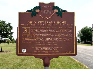
 OHIO VETERANS HOME
3416 Columbus Rd., Sandusky OH
There actually are two Ohio historic markers for the Ohio Veterans Home. One is located directly on Milan Road and the other is in front of the I.F. Mack Building on the home’s grounds. Both markers say the same thing.
Side 1: Following the Civil War, many of Ohio’s disabled and wounded veterans found inadequate provisions for their long-term needs. In response, the Grand Army of the Republic’s Department of Ohio lobbied for a state-operated veterans’ home. In 1886 Governor Joseph B. Foraker signed a bill establishing the Ohio Soldiers’ and Sailors’ Home for honorably discharged veterans. A board of trustees led by Sandusky publisher I.F. Mack selected the site, and the Sandusky community donated the tract of land, utilities, and a connection to the Baltimore and Ohio Railroad. The facility opened in November 1888.
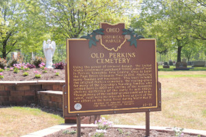 OLD PERKINS CEMETERY
Using the power of eminent domain, the United States Government purchased 9,000 acres of land in Perkins Township, Erie County, Ohio to build the Plum Brook Ordnance Plant in 1941, displacing many families and businesses. This tract included the original Perkins cemetery, the resting-place for many of the township’s founding families who settled here in 1809 and victims of the numerous cholera epidemics of the early to mid-1800s. Though many of the earliest graves could not be located, most were re-interred here as part of the war effort on the home front during World War II.
Bay View / Castalia / Margaretta Township Historical Markers
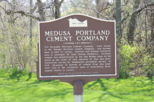 MEDUSA PORTLAND CEMENT COMPANY
Read More about the history of the plant.
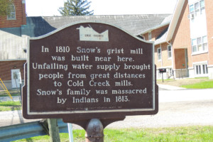 SNOW’S GRIST MILL
In 1820 Docartus Snow of Vermont and others founded a settlement here and called it Cold Creek. He built the first grist mill (of logs) in the Firelands area, upon the offer of 100 acres of land. His mill could grind 15 bushels of corn in 24 hours. But after two years he and the others were driven out by fear of the British and the Indians. Yet they bravely returned the year following. At this time the population of Castalia consisted of three families and two bachelors; twenty-nine persons. The families settling here with the Snows were the Butler’s and the Putnam’s.
Soon corn was missing at Snow’s grist mill; the Indians were stealing it. So, he devised loose boards which, like trap-doors, dumped them out and raised a loud clatter. Some say this caused the Indians to be so angered that they planned revenge. One day, while the men worked at about a mile northward in their fields, on June 2, 1813, a group of Indians (some say they were Pontiac’s and from the Detroit area) attacked the homes. Violently they took all the women and children as prisoners, except those they killed: Snow’s and Butler’s two year old sons, Julia Butler four years old, and Snow’s wife. The children were tomahawked for hiding. Mrs. Snow was dragged from a sick bed. Unable to keep pace with the party, she was killed along the trail. The rest were taken to Detroit, and released the next Fall. Their friends heard what happened soon enough, but could not communicate with them, as Detroit was in British hands. Snow’s son is buried in Castalia cemetery. His second wife later married Philip Cowell; their granddaughter is Mrs. Chas. Dole. Cowell set aside two acres for the cemetery, as his deed stipulated. Two muskrat trappers were later killed by Ottawa Indians in a cabin. Two of them were caught and hanged.
The dam built by Snow for water-power for his mill caused the subterranean water pressure to break out in a new spring in 1820, forming the present Blue Hole. It had a small diameter at first, but repeated cave-ins brought it to the present size by 1914. The Geological Survey of Ohio says of it: “The water Maintains nearly the same temperature winter and summer, and its flow is more uniform than that of the surface streams of the vicinity, though sensibly affected by periods of unusual and widespread drought. The water of the springs is highly charged with lime, rapidly encrusting any object covered by it, and has deposited a sheet of travertine over an area of several square miles in the vicinity.”
The Cold Creek springs area was evidently a favorite camping place for the Indians from the earliest times. They cultivated fields of corn nearby. Game was plentiful, especially wild turkeys and deer; wolves, skunks and rattlesnakes! https://www.villageofcastalia.com/about
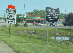 CASTALIA CORPORATE LIMIT MARKER
Located by Cold Creek on Washington St. near the Lutheran Church
Cold Creek Rises here. A stream that never freezes.
Discover more about Castalia, home of the Blue Hole HERE.
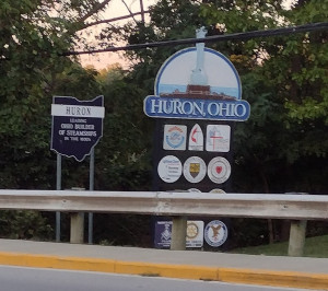
Huron City and Huron Township Historical Markers
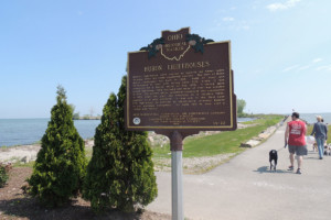
 HURON’S MARITIME HISTORY & HURON LIGHTHOUSE
417 Main Street, Huron, OH
Side 1: Lake Erie commerce has played a central role in the development of Huron. Important among Huron’s maritime industries were shipbuilding and commercial fishing. The city’s shipbuilding industry dates to the first decades of the nineteenth century. Shipyards were located on the Huron River’s west bank, slightly north of this marker, and also upstream at Fries Landing. Among the vessels built at Huron were the Great Western, constructed in 1838 and the first lake ship to have above-deck cabins, and the Golden Age, which, at 286 feet, was the largest craft on the Great Lakes when built in 1886. Huron shipbuilding declined as the nineteenth century drew to a close. Commercial fishing emerged thereafter, serving as Huron’s economic cornerstone for over fifty years. Huron’s fishing enterprises included the Huron, Kishman, Scott, and Zimmerman fish companies. By 1950, however, polluted lake waters ravished the once-lucrative industry. Although shipbuilding and commercial fishing are no longer a part of Huron’s daily life, they each had a profound effect upon the community’s growth for nearly two centuries.
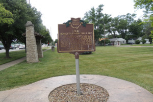 OLD HOMESTEAD ON-THE-LAKE & OLD MEEKER FARM
Old Homestead Beach Association South Park
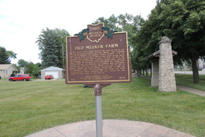 Side 2: In 1837, Aaron Wright Meeker received 160 acres of Lots 26 and 32 from his parents Stephen and Polly Meeker, who originally came to the Firelands from Vermont. Heavily forested, A. W. cut the trees by hand to build a farm on what would become Huron Township’s most valuable tract of land. In 1859, he built The Old Homestead for his family, which still stands today. Upon his death in 1896, his daughters Metta Breckenridge and Hannah Stein inherited the farm and embarked upon separate land development ventures that would turn the old Meeker farm into an area of summer cottages and resort beaches, Chaska Beach in 1925 and Old Homestead in 1927. In Old Homestead, the streets are named in honor of the Native Americans who once claimed the area before the 1805 Treaty of Fort Industry.
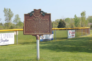 HURON’S FIRST INHABITANTS
Faben’s Park, Huron OH
Huron and Erie County are rich in Native American history. During the construction of the nearby Ohio Route 2 bypass, archeologists in 1976-77 uncovered three Native villages and burial sites. The Anderson site, overlooking the Old Woman Creek estuary, contains artifacts dating to the fifteenth century A.D. The site was once a permanent village, with remains of bowls, fire pits, and even traces of food found among its artifacts. The Jenkins site, also near the estuary, was a winter camp for Indians. Excavators there found several pieces of pottery carbon-dated to 1470 A.D. The final dig, the Enderle site — located west of the Huron River — was strictly a burial site. The discovery of European objects in its graves suggests its creation by a more recent people, such as the Delaware or Wyandot Indians. In 1805, Native Americans in the Firelands signed a land cession treaty at Fort Industry (modern Toledo), and in succeeding years were compelled to leave the region.
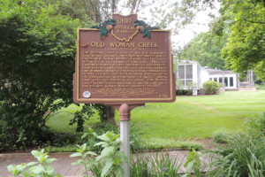 OLD WOMAN CREEK – A feature of Ohio’s Estuaries
2514 Cleveland Road E, Huron, OH – Old Woman Creek State Nature Preserve
Old Woman Creek is one of the few naturally functioning estuary environments – places where chemically-distinct bodies of water meet and mix – left in the western basin of Lake Erie. This ecosystem features diverse habitats of marshlands, sand beaches, and upland forests, supporting plants and animals unique to natural coastal communities. Nearly 300 bird species (including bald eagles), 40 fish species, and hundreds of native plants have been recorded in this area. Old Woman Creek is Ohio’s only national estuarine sanctuary and became a state nature preserve in 1980.
 CHRIST EPISCOPAL CHURCH
120 Ohio St., Huron OH
The Episcopal Society of Huron was organized in 1837, the Rev. F. M. Levenworth, pastor. The cornerstone of this building was laid May 23, 1838; it is the oldest church building in Huron, standing near what had been the original southern limit of the village. The Rev. Samuel Marks became pastor in 1839 and continued for over 40 years. This marker commemorates the church’s sesquicentennial observance in 1988.
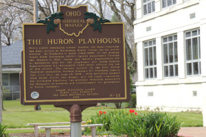 THE HURON PLAYHOUSE
325 Ohio St., Huron OH
Ohio’s oldest continuing summer theatre, the Huron Playhouse has been housed at McCormick Middle School for its entire history. Dr. Frederick G. Walsh (1915-1999) of the Bowling Green State University (BGSU) Speech Department founded the theatre in 1949. Huron met Walsh’s expectations for an attractive site for the playhouse, and Huron Schools Superintendent R.L. McCormick (1904-1978) offered the use of this school. The curtain opened on the first Huron Playhouse production, Norman Krasna’s hit Broadway comedy John Loves Mary, on June 29, 1949. With persisting support from BGSU, actors and alumni, and the local community, the acclaimed Playhouse has provided theatrical experience for thousands of students and entertainment for generations of Huron residents.
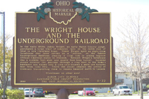 THE WRIGHT HOUSE AND THE UNDERGROUND RAILROAD & OLD MAIN STREET
417 Main St., Huron OH
Side 1: In the early 1800s, Jabez Wright, an early Huron County judge, purchased a large tract of lakeside land on the north side of what is now Cleveland Road. There Wright built an eight-room farmhouse that later served as a “station” on the fabled Underground Railroad, playing a vital role in aiding fugitive African-American slaves to freedom. Beneath Wright’s farmhouse was a sixteen foot-wide and ninety foot-long tunnel. Escaped slaves entered the passage through a trap door in the home’s basement and exited into a corn crib located a mere one hundred feet from Lake Erie. There the slaves awaited the arrival of rowboats transporting them to vessels heading north to Canada.
 Side 2: OLD MAIN STREET – After the passage of the Federal Housing Act of 1949, a concerted, nationwide effort toward modernizing aging urban areas began. As a part of this trend, the city of Huron began demolition of 38 buildings along Main Street in 1969. Completed in 1975, the federally subsidized Huron urban-renewal project reshaped much of the community’s downtown, adding the modern-day boat basin. Structures removed included the Harbor Inn, the Huron Dairy, and the Vermilion Rubber Company, along with many residential buildings. Throughout the course of the undertaking, many citizens opposed the alteration of Main Street. The project was carried through, however, and the boat basin is the centerpiece of downtown Huron today.
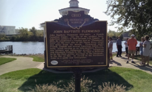 JOHN BAPTISTE FLEMMOND
SE corner of Main Street and Wall Street, Huron OH – In front of the Gazebo near fishing pier parking lot
John Baptiste Flemmond (1770-1827), a French Canadian trader, was one of the earliest Euro-American settlers in what became Erie County. In 1805, he established a trading post at “Flemmond’s Cove” on the east side of the Huron River about two miles from its mouth. Flemmond spoke French, English and several American Indian dialects, often serving as an intermediary between new settlers and indigenous peoples. Flemmond wed Elizabeth Pollock in 1811, in what is believed to be the first settler marriage in the Firelands. In the War of 1812, he served in the Northwest Army as a guide and interpreter. READ MORE
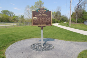
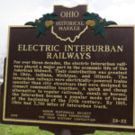 ELECTRIC INTERURBAN RAILWAYS & LAKE SHORE ELECTRIC RAILWAY
N Jim Campbell Blvd, Huron OH – Lake Shore Electric Trail
Side 1: For over three decades, the electric interurban railways played a major part in the economic life of the American Midwest. Their contribution was greatest in Ohio, Indiana, Michigan and Illinois. The interurban railways were electrically-powered trains speedier than city streetcars that were designed to connect communities together. A quick and cheap alternative to regular railroads, canals or horses, the interurban became a popular mode of travel at the beginning of the 20th century. By 1915, Ohio had 2,780 miles of interurban track.
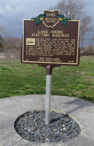 Side 2: Lake Shore Electric Railway (LSE) operated routes from Cleveland to Detroit via Avon Lake, Lorain, Vermilion, Huron, Sandusky and Toledo. For many years, Huron residents used the LSE Railway to travel to neighboring towns and students relied on the trolley for school transportation. The LSE carried hundreds of tourists to lakeshore communities and Cedar Point. In addition to passengers, the LSE transported industrial and package freight, as well as farm produce and fish. The increased popularity of the automobile combined with the Great Depression eventually led to the demise of the electric railway.
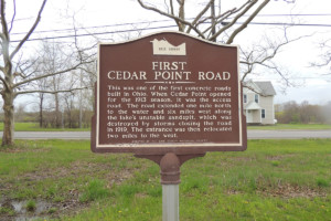 FIRST CEDAR POINT ROAD
2715 Cleveland Road W, Huron OH, .6 miles west of Rye Beach Rd.
this was one of the first concrete roads built in Ohio. When Cedar Point opened for the 1913 season, it was the access road. The road extended one mile north to the water and six miles west along the lake’s unstable sandspit, which was destroyed by storms closing the road in 1919. The entrance was then relocated two miles to the west.
 THE FIRELANDS
Marker can be reached from the intersection of University Drive and Rye Beach Road (County Route 122). It is at Bowling Green State University Firelands Campus, between Foundation Hall, George Mylander Hall and Cedar Point Center. The Origin of the Firelands markers in front of both Firelands Hospital and BGSU Firelands were installed around the same time and the text on each is exactly the same.
Text: The history of the Firelands is linked to the American Revolutionary War. During the British raids of 1777 and 1779 the Connecticut towns of Danbury, East Haven, New Haven, Fairfield, Norwalk, Greenwich, Groton, Ridgefield and New London were destroyed by fire. In 1781 the last major British raid was commanded by Benedict Arnold, who had turned traitor. Lives were lost and many homes and shops were burned. For ten years the townspeople petitioned the General Assembly of Connecticut for relief. The Assembly was sympathetic with their plight but they were unable to make restitution. Finally on May 10, 1792 the Connecticut legislature set aside 500,000 acres of land for the sufferers. The tract was In the western most part of the Connecticut Western Reserve in what is now the state of Ohio, named the Fire Sufferers Land or Fire Land. The tract consists of all of the present-day counties of Huron and Erie as well as Danbury Township in Ottawa County and Ruggles Township in Ashland County. Many of the new Firelands communities were named for their Connecticut counterparts. After years of delay, only a few of the original “Sufferers” were able to move to the new land; most were too old to migrate. Their younger heirs either made the move or sold the land.
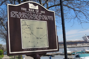
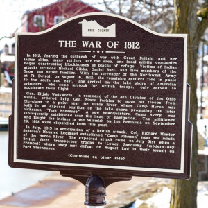 THE WAR OF 1812
Marker can be reached from the intersection of Main Street and Cleveland Road West. It is at the Huron Boat Basis (Anchor Point).
Side 1: In 1812, fearing the outbreak of war with Great Britain and her Indian allies, many settlers left the area, and local militia companies began constructing blockhouses as places of refuge. Victims of Indian attacks included Michael Gibbs, Daniel Buel, and five members of the Snow and Butler families. With the surrender of the Northwest Army at Fort Detroit on August 16, 1812, the remaining settlers fled in panic to the south and east. The arrival on the lake shore of American prisoners, who some mistook for British troops, only served to accelerate their plight. General Elijah Wadsworth, in command of the 4th Division of the Ohio Militia, ordered Brigadier General Simon Perkins to move his troops from Cleveland to a point near the Huron River where Camp Huron was built in an exposed position on the lake shore prompting its later nickname, “Fort Nonsense.” A new headquarters, Camp Avery, was subsequently established near the head of navigation. The militiamen who fought the Indians in the Skirmish on the Peninsula on September 29, 1812 were dispatched from this post. In July, 1813 in anticipation of a British attack, Colonel Richard Mentor Johnson’s Mounted Regiment established “Camp Johnson” near the mouth of the Huron River. The expected attack came on July 31st when a British fleet transported troops to Lower Sandusky (modern-day Fremont) where they met defeat on August 2nd in their assault on Fort Stephenson. Photograph credit: J. J. Prats
 HURON CORPORATE LIMIT MARKER
Leading Ohio Builder of Steamships in the 1830s.
Learn more about Huron and its ship building history HERE.
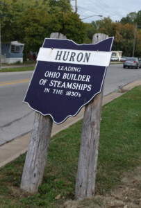 HURON CORPORATE LIMIT MARKER
Location: On Cleveland Rd., just east of Rye Beach Road
Leading Ohio Builder of Steamships in the 1830s.
Learn more about Huron and its ship building history HERE.
It is anticipated that this marker will be temporarily removed during the construction project planned for this road.
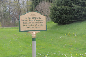
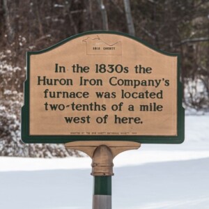 HURON IRON COMPANY FURNACE
Marker is near Vermilion, Ohio, at the intersection of State Road (Ohio Route 60) and Darrow Road, on the right when traveling south on State Road.
In the 1830s the Huron Iron Company Furnace was located two-tenths of a mile west of here.
Erected 1989 by the Erie County Historical Society.
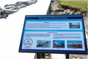
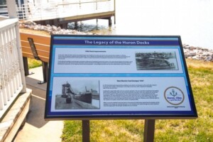 The Legacy of Huron Docks – 1906 Dock Improvements. In 1906 the Army Corps of Engineers widened Huron Harbor from 120 to 180 feet and extended the west break wall. In 1937 the docks were improved by installing a new electric car dumper on the north side of slip #1. READ MORE
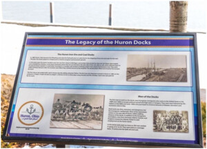 The Legacy of the Huron Docks – The Huron Iron Ore and Coal Docks/Men of the Docks. The Huron Iron Ore and Coal Docks. In 1882 Huron, Ohio became the Wheeling and Lake Erie Railroad’s port on Lake Erie for the shipping of iron ore and coal. For the next 100 years the docks played an integral part in Huron’s progress and economic growth. READ MORE
 The Legacy of the Huron Docks – Self-Unloaders/Boats that Came to Huron. Business at the ore docks was strong through the 1970s. An all time record was set in 1979 when 151 boats shipped in 2,784,000 tons of ore. As higher grade iron-ore grew scarce it was replaced by lower grade taconite. It became the primary cargo for boats in the late 1970s. READ MORE
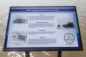 Legacy of the Huron Docks – Early Boats/Wooden Steam Ships and Barges/Bulk Freighters/Whalebacks. Early Boats. In the 1800s, schooners were the main cargo vessels of the Great Lakes, linking the growing towns of the Midwest with the East Coast. One of the largest schooners to sail the Great Lakes was built just a few miles up the Huron River at Fries Landing by Valentine Fries. READ MORE
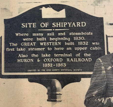 SITE OF SHIPYARD – Where many sail and steamboats were built beginning 1830. the GREAT WESTERN built 1832 was first lake steamer to have an upper cabin. Also the lake terminal of the HURON & OXFORD RAILROAD 1852-1863.
The marker was erected by the Erie Co. Historical Society just South of where the old Twine House restaurant was located in Huron. It has disappeared and the Huron Historical Society is trying to locate it. They believe it was removed when the Twine House burned down. The city of Huron has no idea what happen to it. Gone but not forgotten. Read about its dedication HERE.
Oxford Township Historical Markers
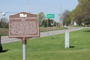 BLOOMINGVILLE SETTLEMENT 1810
Marker is on West Mason Road just east of Taylor Road (County Route 112), on the left when traveling east. It is at Bloomingville Cemetery.
A blockhouse was erected in 1811 on the northwest side of the then Flemmonds Trail. The key establishments of a church, school, post office, inn, grist mill and cemetery were founded in the first seven years. The Bank of Sandusky Bay at Bloomingville was built in 1817 of brick. The bank never received a charter and bank notes were printed but never issued. Milk sickness, “trembles,” and cholera caused mass burials in the nearby cemetery.
Erected by Wensink Seed Farms and the Erie County Historical Society. For more information on Bloomingville, visit the Sandusky Library’s page HERE.
Vermilion City and Vermilion Township Historical Markers
 THE FORMER SITE OF CRYSTAL BEACH PARK
Crystal Beach Park opened for the first of its 56 seasons on Decoration Day (now referred to as Memorial Day) Thursday May 30, 1907. The 42 ½ acres had been owned by the George Shadduck family since 1854. It was at one time a stagecoach stop and later became a popular picnic grove for an ever growing number of visitors.
The founders of Crystal Beach Park were George and Josephine Blanchat. They purchased the property in 1906. The twenty-two and a half acres along Lake Erie developed into the amusement park.
The twenty acres south along the roadway, where the shopping center is today, was the parking lot. The name of the park is attributed to Josephine Blanchat. This occurred when on a walk along the beach with her husband she had picked up a handful of sand and remarked, “It looks like crystal.”
Crystal Beach Park started with just a beer garden that later was turned into a dining hall. A carousel and shooting gallery completed the earlier attractions. Over the years a variety of other rides and concessions were added. There were popular rides like the Thriller, Tumble Bug, Dodgem. Ferris Wheel, Loop-O-Plane, Kiddie Rides, Left in the Dark and Rocket Ships. The park hosted at one time or another as many as 15-20 rides. A midway of concession games, a miniature 18 hole golf course, and for a time Jungle Larry’s Safari, offered other sources of enjoyment.]
During the big band era of the 1930’s through the 1950’s such band leaders as Tommy Dorsey, Stan Kenton, Guy Lumbardo, Gene Krupa, Louis Armstrong, Duke Elington, Les Brown with Doris Day, Vaughn Monroe, Sammy Kaya, Cab Calloway, Xavier Cugal, Ray Anthonly, Ralph Flanagan, and Woody Harman, performed before large audiences at the Crystal Beach ballroom. Singing groups such as the Everly Brothers, Four Freshmen, Four Lads and Kingston Trio later joined the list of famous entertainers.
Following the passing of George and Josephine Blanchat the ownership of the park was taken over by their daughters Thelma and Eleanor. With their husbands Jim Calvert and Jimmy Ryan (manager), and the grandchildren Marlene Calvert (Feldkamp), and Calvert (Mueller) and Tom Ryan the operation of a family owned park would continue until it was sold in 1962.
Dedicated to all those who worked at and remember Crystal Beach Park. READ MORE
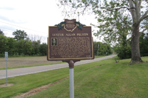 LESTER ALLAN PELTON
Risden & Lake Road, Vermilion Township, OH- Cuddeback Cemetery
Lester Allan Pelton, “the Father of Hydroelectric Power,” was born on September 5, 1829, a quarter of a mile northwest of this site. He spent his childhood on a farm a mile south of this site and received his early education in a one-room schoolhouse that once sat north of this site. In the spring of 1850, he and about twenty local boys, left for California during the great gold rush west. Pelton did not find gold, but instead invented what was commonly known as “the Pelton Water-Wheel,” which produced the first hydroelectric power in the Sierra Nevada Mountains in California in 1887. The Water-Wheel was patented on August 27, 1889. Currently variations of it are still commonly used to generate electric power throughout the world. Pelton died in California on March 14, 1908. He is buried at Maple Grove Cemetery in Vermilion. READ MORE
 LAKE SHORE ELECTRIC RAILWAY
Rotary Park, located at base of Vermilion’s Water Tower
At this site the Lake Shore Electric Railway crossed a bridge that spanned the Vermilion River. The western abutment of the former bridge is plainly visible just below along the river bank. Widely known as the “Greatest Electric Railway in the United States,” the flaming orange trolley cars of the Lake Shore Electric Railway transported people and freight for thirty-seven years (1901-1938) along the southern Lake Erie shores from Cleveland to Toledo often reaching speeds of sixty miles per hour. The interurban line played a primary role in the development of the western Cleveland suburbs and also carried throngs of summer visitors to Lake Erie recreation facilities at Avon Beach Park, Linwood Park, Crystal Beach, Mitiwanga, Ruggles Grove, Rye Beach, and Cedar Point. The power lines still standing along the system’s right-of-way attest to the fact that it also assisted in bringing electric power to the entire region.
 HURON IRON COMPANY
Route 60 (State Rd) near Darrow Road, Vermilion OH
In the 1830s the Huron Iron Company’s furnace was located two-tenths of a mile west of here.
Furnaces on the Vermilion River – Iron – About 60 feet north of Huron Street along the riverfront were two stone foundations, round in shape 10′ in diameter and 2′ high. Around the foundations the ground was tinged red, the sign of iron ore. These two furnaces were the first stacks of the Geauga Iron Company of Painesville built in 1828-30. They had a dock and warehouse nearby on the river. Later they moved back on the ridge as the Huron Iron Company west of the State Road. This business operated for many years until coke made charcoal furnaces obsolete. The Huron Iron Company ceased operations in 1865. for more info about the history of the Vermilion River click HERE.
 VERMILION – ERIE COUNTY
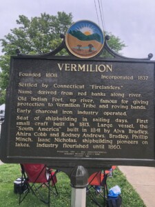
Main Street (Ohio Route 60) north of Ohio Street, on the right when traveling north. Located in Victory Park.
Side 1 – Vermilion
Founded 1808, incorporated 1837.
Settled by Connecticut “Firelanders.” Name derived from red banks along river. Old Indian Fort, up river, famous for giving protection to Vermilion Tribe and roving bands. Early charcoal iron industry operated. Seat of shipbuilding in sailing days. First small craft built in 1813. Large vessel, the “South America” built in 1841 by Alva Bradley, Ahira Cobb and Rodney Andrews. Bradley, Phillip Minch, Isaac Nicholas, shipbuilding pioneers on lakes. Industry flourished until 1860.
Erected 1953 by the Ohio Sesquicentennial and the Sandusky Register-Star-News, founded in 1833.
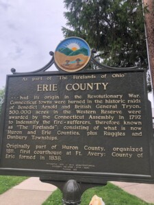 Side 2 – Erie County
As part of “The Firelands of Ohio” Erie County had its origin in the Revolutionary War. Connecticut towns were burned in the historic raids of Benedict Arnold and British General Tryon. 500,000 acres in the Western Reserve were awarded by the Connecticut Assembly in 1892 to indemnify the fire-sufferers, therefore known as “The Firelands;” consisting of what is now Huron and Erie Counties, plus Ruggles and Danbury Townships.
Originally part of Huron County, organized 1811, first courthouse
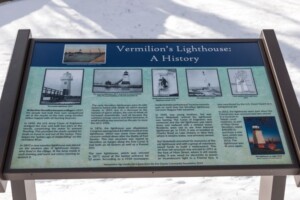 VERMILION LIGHTHOUSE
Located in Harborview Park
In 1847 a lighthouse was placed on the western pier. It was replaced by new lighthouse, which was erected in 1877, and stood at the harbor entrance for 52 years. In 1876, the lighthouse was dilapidated. Congress appropriated $3,000 to build an iron lighthouse, which was made from obsolete cannons melted down after the Battle of Fort Sumter. It stood on the site for 52 years. In 1929 it was dismantled. However, the Wakefield brothers erected this 34-foot-tall structure in 1991 at the foot of Main Street, where it still stands today. READ MORE about the history of this structure and then marker’s text.
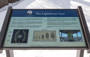 THE LIGHTHOUSE LENS
Location: Marker is on Main Street north of Huron Street, on the left when traveling north. It is at the foot of Main Street in Harbor View Park near the Vermilion lighthouse. This marker is the one of the left. The Vermilion Lighthouse is on the grounds.
The lens in Vermilion’s lighthouse is powered by a single, 100-watt-equivalent LED bulb, no more than an ordinary household lamp. Yet its light reaches 10 miles out across Lake Erie. The technology that makes this possible was developed in the 1800s by Augustin-Jean Fresnel (pronounced Fruh-nell). Before that time, lighthouses were lit with single or multiple lamps burning whale oil. READ THE FULL TEXT
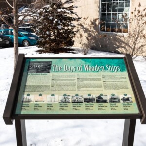 DAYS OF WOODEN SHIPS – WOOD SHIPBUILDING IN VERMILION
Location: Liberty Avenue (U.S. 6) west of Grand Street, on the right when traveling west. It is at Friendship Park which is on the grounds of the public library. 5680 Liberty Ave, Vermilion OH 44089.
Solomon Parsons and Captain William Austin, two of Vermilion’s earliest settlers, were the founders of local shipbuilding legacies. Parsons is credited with building the first schooner in Vermilion in 1814. READ THE FULL TEXT
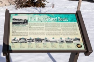 THE DAYS OF STEEL BOATS
STEEL SHIPBUILDING IN VERMILION
Location: Liberty Avenue (U.S. 6) west of Grand Street, on the right when traveling west in Vermilion. It is at Friendship Park which is on the grounds of the public library.
By 1920 it was apparent that the building material of choice was steel. Between 1920 and 1957 over 25 steel boats were built in Vermilion. The establishment of the American Ship Building Company in nearby Lorain and other supporting industries such as steel mills and railroads, drained Vermilion of blacksmiths, carpenters, and ship carpenters — a workforce necessary for crafting wooden boats. READ THE FULL TEXT

FIRELANDS “SUFFERERS”
Located on Liberty Avenue (U.S. 6) 0.2 miles east of Main Street, on the right when traveling west. The marker is on the north side of the street, just a few steps to the east of the public comfort station.
In 1792 the half mil. acres of the Firelands were given to CT property owners of New London, New Haven, East Haven, Greenwich, Danbury, Fairfield, Ridgefield and Groton as recompense for land lost due to British fire raids fueled by anger over the citizens’ aid to the Continental Army. It is the only land ever granted to civilian victims of war in American History. Firelands Chapter Daughters Of The American Revolution.

THE KISHMAN FISH COMPANY
Marker is at or near 5472 Liberty Avenue, Vermilion OH
Adam Kishman began his fishing business in 1864, four miles east of Vermilion, on the shore of Lake Erie. He used simple nets and boats to harvest his catch. His work force consisted of family members and local farmers, who assisted in their spare time. The fish were packed on ice, which had been harvested from Lake Erie, and then distributed by wagon and rail.
In 1905, Adam’s son, Henry, relocated the thriving business to the west bank of the Vermilion River and named it The Kishman Fish Company. They started with one tug and the operation increased rapidly. With advancements in technology, such as diesel power and electricity, the business continued to grow and expanded to three locations along the south shore of Lake Erie. In 1931, Henry’s son, Lester, became involved in the family business and; upon Henry’s death in 1948, became President.
Through the years, The Kishman Fish Company had become an important part of the local economy and history of Vermilion. In the 1970s, commercial fishing began to decline due to overfishing and environmental and legislative restrictions. The Kishman Fish Company closed in 1984. The Fisherman’s Bend condominiums now occupy the. former site of The Kishman Fish Company.
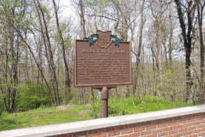
Village of Milan, Milan Twp. & Avery Historical Markers
 CAMP AVERY
Marker is near Avery on River Road 0.3 miles south of East Mason Road, on the left when traveling south.
1811 One-fourth mile southwest from the site on the brow of the hill overlooking the eastern bank of the Huron River, Gen. Simon Perkins, commanding the Ohio Militia, built the fortifications and block house of Camp Avery for protection of early settlers from British and Indians.
County Seat – 1811 On this site was located Avery, first county seat of Huron County. Here stood the two story log house used as a court house and jail. 1818 County seat moved from here to Norwalk. 1838 Erie County was established from the northern part of Huron County.
This locality was frequented by tribes of Indians: Ottawas, Miamis, Chippewas and Senecas. READ MORE
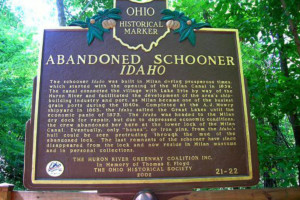
Abandoned Schooner Idaho, Image courtesy of Ohio History Connection
ABANDONED SCHOONER IDAHO
Unable to locate this marker, formerly identified as Mason Road (Cty Rd #13) Trailhead, Milan Township, just north of Mason Rd.
The schooner Idaho was built in Milan during prosperous times, which started with the opening of the Milan Canal in 1839. The canal connected the village with Lake Erie by way of the Huron River and facilitated the development of the area’s shipbuilding industry and port, as Milan became one of the busiest grain ports during the 1840s. Completed at the A. J. Mowry shipyard in 1863, the Idaho sailed the Great Lakes until the economic panic of 1873. The Idaho was headed to the Milan dry dock for repair, but due to depressed economic conditions, the crew abandoned her here at the lower lock of the Milan Canal. Eventually, only “bones”, or iron pins, from the Idaho’s hull could be seen protruding through the mud of the abandoned lock. The last remnants of the schooner have since disappeared from the lock and now reside in Milan museums and in personal collections.

MILAN’S HOGBACK
30 N Edison Dr, Milan OH
The ridge beginning at the Edison Birthplace and descending to the Village Creek 1/4 mile north of this spot was known, even in Edison’s time, as the Hogback. Shown on an 1805 Moravian map, the street on which you are standing was an Indian trail leading north to Lake Erie. The present street, Edison Drive, was first named Liberty Street and then change to Choate to honor George Washington Choate, a carding and fulling mill owner, whose home was 100 feet north of here. For more information and nearby markers click HERE.
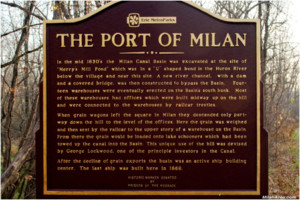 THE PORT OF MILAN
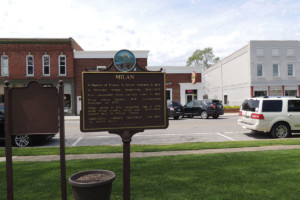 MILAN
MILAN
Marker is on N. Main Street, on the left when traveling south. Located in Lake Front Park.
Birthplace of Thomas A. Edison, February 11, 1847.
• A Moravian village, Pequotting, 1804–1809.
• First permanent white settlers came in 1816.
• Milan village platted, 1817; incorporated February 23, 1833.
• Ship’s canal to lake completed July 4, 1839, made Milan leading wheat port, 1839–1864, second only to Odessa, Russia.
• Shipbuilding industry flourished, 1842–1867; 75 vessels built.
 ERIE COUNTY AS PART OF “THE FIRELANDS OF OHIO”
Marker is on N. Main Street, on the left when traveling south. Located in Lake Front Park.
As part of “The Firelands of Ohio”… Erie County had its origin in the Revolutionary War. Connecticut towns were burned in the historic raids of Benedict Arnold and British General Tyron. 500,000 acres in the Western Reserve were awarded by the Connecticut Assembly in 1792 to indemnify the fire-sufferers, therefore known as “The Firelands”: consisting of what is now Huron and Erie Counties, plus Ruggles and Danbury Townships. Originally part of Huron County, organized 1811, first courthouse at Fort Avery: County of Erie formed in 1838.
 MILAN CANAL BASIN
Marker is on North Edison Drive, 0.1 miles north of Front Street, on the left when traveling north.
Milan was a leading Great Lakes port after the completion of the 3-mile Milan Canal in 1839. Center of activity was the Milan Basin at this site where produce was brought from area farms for shipment to lake and world ports through 14 warehouses by as many as 20 schooners a day. Seventy-five vessels were built in the basin. Railroad competition and the flood of 1868 ended Milan’s port activity. READ MORE
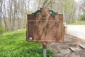 BIRTHPLACE OF THOMAS A EDISON (1847-1931) & EDISON RECALLS MILAN
Marker is on East Edison Drive, on the right when traveling south, in front of Edison museum
Side 1: One of America’s most prolific and important inventors, Thomas Alva Edison was born in this house in 1847. Designed by his father, Samuel Edison, a shingle maker by trade, this small gabled brick cottage was built in 1841. Though the Edisons moved to Port Huron, Michigan, in 1854, when he was seven, Edison cherished the memories of his early boyhood here and acquired the home from his sister’s family in 1906. Edison’s daughter Madeleine Edison Sloane opened the home to the public as a memorial to the great inventor in 1947, the centennial of his birth. It became a registered National Historic Landmark in 1965.
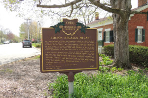 Side 2: My recollections of Milan are somewhat scanty as I left the town when I was not quite seven years old. I remember the wheat elevators on the canal, and Gay shipyard; also the launching of new boats, on which occasion the piece of land called the “Hogbac” would be filled with what seemed to me to be the entire population of the Town who came to witness the launching. I also recall a public square filled at times with farmers’ teams, and also what seemed to me to be an immense number of teams that came to town bringing oak staves for barrels. I can just remember seeing a number of Prairie Schooners encamped in front of our house. This was about 1849 or 1850, when I was but a mere infant, and I learned afterwards that these Prairie Schooners were carrying adventurers going to California to hunt for gold. Yours very truly,
Birmingham Historical Markers
M.A. Harrison Airfield, Image courtesy of Ohio History Connection
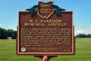
M A HARRISON AIRFIELD
Location: No longer viewable — Our thanks to John Wolshuck who wrote: I searched for this marker where indicated on your map. Strike one. I figured it must be near other such markers on the Milan Towpath MetroPark. Strike two. I searched the Ohio Historical Marker website and found a different location indicated. It is/was located on the former Metropark’s Greenway land that is now posted as private. It was originally reported missing in 2020.
Marion A. Harrison established M A Harrison Memorial Airfield, formerly Harrison Airport, in 1946 on land encompassing 80 acres. This facility served to promote aviation activities in the Birmingham community with flight charters, flight instruction, and rides. Birmingham Metal Products was located here during World War II producing fighter aircraft fuel parts, and the airfield was used to train civilian pilots. Today, it remains dedicated to flight.
Birmingham School Entrance and Marker
Marker is near 15218 Edison Hwy, Wakeman OH
Birmingham School was built in 1916 and served as a high school until school districts merged in 1954, and it was repurposed into an elementary school. In 1988, school districts merged again and the Birmingham School was closed. READ MORE
Kelleys Island Historical Markers
T HE KELLEYS ISLAND NORTH SIDE CRUSHER TRAIL
Less than 1/5 mile long, this trail was established in 2025 and tells the story of quarrying on the Island and how the ruins of the crusher building were used. There are 7 plaques (2 overlook a former quarry pit) and a dedication plaque.
See all the plaques HERE as well as some additional photos.
 THE NORTH QUARRY & THE KELLEY’S ISLAND LIME & TRANSPORT CO.
This plaque is located on the shore just north of the State Park Beach. This was the location of the North Quarry dock, the lime kilns and the Northside quarry operation.
On this site stood the Kelley Island Lime & Transport Company, which began quarry operations here in 1886 and became the largest producer of lime in the world. The industrial complex included 16 lime kilns and a rail system connecting the quarry to the kilns and docks where steam-powered barges and freighters were loaded with stone and lime for transport to various Great Lakes ports. The workforce was largely composed of immigrants form Italy, Finland, and Eastern Europe. The quarry yielded stone for building and road construction, flux stone used for the manufacture of steel and lime used for mortar, plaster and for agriculture. The quarry operations here played a significant role in the development of the Great Lake shipping industry and the growth and economy of Ohio and the nation. On October 7, 1903, the steam barge “Adventure” caught fire while moored at the warehouse and the captain and crew narrowly escaped with their lives. A tug towed the burning vessel out into North Bay and the wreck lies several hundred feet offshore near Long Point. It is one of many shipwrecks now protected by law as a legacy of Ohio’s rich maritime heritage and a reminder of the hazards that were endured by the men and women who made their livelihood on our inland seas.
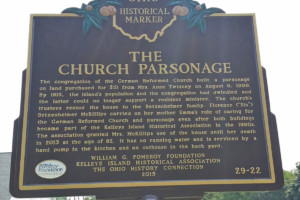
The Church Parsonage, Kelleys Island. Image courtesy of Leslie Korenko
THE GERMAN REFORMED CHURCH – PARSONAGE
Located at 224 Division St, this is a 2-sided marker.
Side 2 – The congregation of the German Reformed Church built a parsonage on land purchased for $51 from Mrs. Anne Twidney on August 8, 1888. By 1915, the island’s population and the congregation had dwindled and the latter could no longer support a resident minister. The church’s trustees rented the house to the Betzenheimer family. Florence (“Sis”) Betzenheimer McKillips carried on her mother Emma’s role of caring for the German Reformed Church and parsonage even after both buildings became part of the Kelleys Island Historical Association in the 1980s. The association granted Mrs. McKillips use of the house until her death in 2013 at the age of 92. It has no running water and is serviced by a hand pump in the kitchen and an outhouse in the back yard.
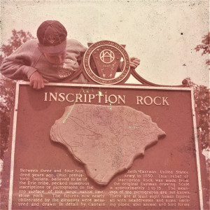 INSCRIPTION ROCK – KELLEYS ISLAND
Installed by the Ohio State Archeological and Historical Society, this plaque was removed sometime in the 1960-70s. It read: Between three and four hundred years ago, Ohio prehistoric Indians, believed to be of the Erie Tribe, pecked numerous inscriptions of pictographs on the top surface of this large native limestone rock. The figures, now nearly obliterated by the elements were measured and drawn in detail by Captain Seth Eastman, United Sates Army, in 1850. This relief of Inscription Rock was made from the original Eastman drawing. Scale is approximately 1 to 15. The meanings of the pictographs are not know. There are at least eight human figures, all with headdresses and some smoking pipes, also animal and bird forms.
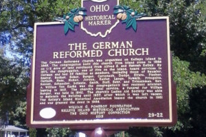
German Reformed Church, Kelleys Island. Image courtesy of Leslie Korenko
THE GERMAN REFORMED CHURCH
There are two different sides to this marker – one for the church itself and the other for the parsonage next door. They are located at 224 Division Street, just a short walk from the downtown area.
Side 1: The German Reformed Church was organized on Kelleys Island in 1865. The congregation built this church from island stone in 1866 on 1/2 acre of land purchased from Alfred S. and Hannah Kelley. By 1871, the congregation, one of five on the island, heard services in German and had 25 families as members, including those of Baumler, Beatty, Becker, Boker, Burger, Cattenach, Dodge, Elfers, Fischer, Gerlach, Hess, Huber, Jordon, Keifer, Lange, Nowalk, Pringnitz, Renter, Schaedler, Scheele, Smith, Stoll, Suhr, and Trieschman. Rev. A. William Von Kaske was the congregation’s last resident minister, leaving in 1915. The church’s final service, a funeral for William Burger, was held in 1942. The church’s Ladies Aid Society was able to maintain the building until 1957, after which it was left vacant. The Kelleys Island Historical Association leased the church in 1981 and was granted the deed in 1986.
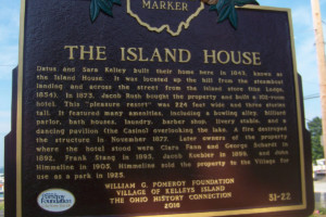
The Island House, Kelleys Island. Image courtesy of Leslie Korenko
THE ISLAND HOUSE
Located in the downtown park at the intersection of Division and Lakeshore roads.
Datus and Sara Kelley built their home here in 1843, known as the Island House. It was located up the hill from the steamboat landing and across the street from the island store (the Lodge, 1854). In 1873, Jacob Rush bought the property and built a 102-room hotel. This “pleasure resort” was 224 feet wide and three stories tall. It featured many amenities, including a bowling alley, billiard parlor, bath houses, laundry, barber shop, livery stable and a dancing pavilion (the Casino) overlooking the lake. A fire destroyed the structure in November 1877. Later owners of the property where the hotel stood were Clara Fann and George Schardt in 1892, Frank Stang in 1895, Jacob Kuebler in 1899 and John Himmelien in 1905. Himmelien sold the property to the Village for use as a park in 1925.
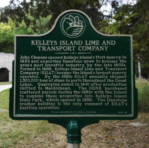 KELLEYS ISLAND LINE & TRANSPORT CO. (side 1)
End of Division St. through the parking lot by the trail entrance.
READ MORE about the history of this company and the limestone that they quarried.
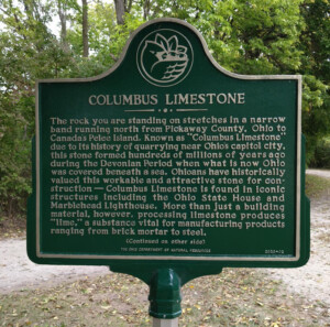 COLUMBUS LIMESTONE (side 2)
North end of Division Street